Surveying and Mapping Technicians: Job Description
Perform surveying and mapping duties, usually under the direction of an engineer, surveyor, cartographer, or photogrammetrist, to obtain data used for construction, mapmaking, boundary location, mining, or other purposes. May calculate mapmaking information and create maps from source data, such as surveying notes, aerial photography, satellite data, or other maps to show topographical features, political boundaries, and other features. May verify accuracy and completeness of maps.
Featured schools near , edit
What Tasks Do Surveying and Mapping Technicians Do?
Typical responsibilities of surveying and mapping technicians include:
- Position and hold the vertical rods, or targets, that theodolite operators use for sighting to measure angles, distances, and elevations.
- Check all layers of maps to ensure accuracy, identifying and marking errors and making corrections.
- Design or develop information databases that include geographic or topographic data.
- Monitor mapping work or the updating of maps to ensure accuracy, inclusion of new or changed information, or compliance with rules and regulations.
- Produce or update overlay maps to show information boundaries, water locations, or topographic features on various base maps or at different scales.
- Determine scales, line sizes, or colors to be used for hard copies of computerized maps, using plotters.
- Compile information necessary to stake projects for construction, using engineering plans.
- Identify and compile database information to create requested maps.
Key Skills and Knowledge
Effective surveying and mapping technicians rely on a mix of skills and domain knowledge.
Top Skills
These are the skills that matter most in this role, rated on an importance scale of 0 to 5:
Knowledge Areas
Other Surveying and Mapping Technicians Job Titles
People in this occupation may also be known by titles such as:
- Aerial Photograph Interpreter
- Aerotriangulation Specialist
- Assessment Technician
- Ax Survey Worker
- CAD Technician (Computer Aided Design Technician)
- Cartographic Aide
- Cartographic Drafter
- Cartographic Technician
Employment and Demand
There are roughly 34,470 surveying and mapping technicians working in the United States today. Employment is projected to decline by -2.7% over the projection horizon.

Salary for Surveying and Mapping Technicians
| Statistic | Value |
|---|---|
| Annual median | $123,658 |
| Hourly median | $59.45 |
| 10th percentile | $73,551 |
| 25th percentile | $98,604 |
| 75th percentile | $148,711 |
| 90th percentile | $173,764 |
Wages vary widely based on experience, location, and industry.

Pay by State
| State | Annual median salary |
|---|---|
| Nevada | $75,660 |
| Alaska | $73,320 |
| District of Columbia | $72,230 |
| California | $71,860 |
| Minnesota | $66,080 |
| Maryland | $64,460 |
| Wyoming | $61,790 |
| Washington | $61,660 |
| New Jersey | $61,170 |
| Connecticut | $60,150 |
| Ohio | $59,400 |
| New Hampshire | $59,180 |
| Colorado | $58,370 |
| Illinois | $58,100 |
| Oregon | $57,990 |
| New York | $57,900 |
| Pennsylvania | $56,400 |
| North Dakota | $56,150 |
| New Mexico | $55,760 |
| Wisconsin | $54,760 |
| Indiana | $54,730 |
| Arizona | $54,410 |
| Iowa | $53,210 |
| Vermont | $52,360 |
| Hawaii | $51,750 |
| Maine | $51,370 |
| Michigan | $50,660 |
| Rhode Island | $50,510 |
| Missouri | $50,270 |
| Massachusetts | $50,120 |
| Kansas | $49,850 |
| North Carolina | $49,780 |
| Montana | $49,310 |
| Virginia | $49,040 |
| South Dakota | $49,000 |
| Texas | $48,930 |
| Delaware | $48,860 |
| Utah | $48,720 |
| Tennessee | $48,320 |
| Nebraska | $47,940 |
| Arkansas | $47,580 |
| Louisiana | $47,580 |
| Idaho | $47,120 |
| Florida | $46,740 |
| Alabama | $46,260 |
| Kentucky | $45,880 |
| West Virginia | $45,630 |
| Mississippi | $45,490 |
| Oklahoma | $44,720 |
| South Carolina | $43,410 |
| Georgia | $43,190 |
| Guam | $36,210 |
| Puerto Rico | $31,450 |
Top-Paying U.S. Regions
Compensation for surveying and mapping technicians shift depending on where you work. These regions lead on median pay:
| Region | Median annual wage | Share of U.S. jobs | Location quotient |
|---|---|---|---|
| Far Western US | $68,448 | 11.2% | 0.84 |
| Middle Atlantic | $58,473 | 9.0% | 0.61 |
| Great Lakes | $55,868 | 9.1% | 0.65 |
| Plains States | $54,176 | 6.3% | 1.12 |
| Rocky Mountains | $54,072 | 7.9% | 2.29 |
| New England | $53,991 | 3.3% | 0.85 |
| Southwest | $49,206 | 18.1% | 1.52 |
| Southeast | $47,280 | 34.9% | 1.59 |
Where the Jobs Cluster
| Metro area | State | Median annual wage | Employment |
|---|---|---|---|
| San Jose-Sunnyvale-Santa Clara, CA | CA | $95,150 | 190 |
| Reno, NV | NV | $81,300 | |
| Los Angeles-Long Beach-Anaheim, CA | CA | $79,880 | 810 |
| San Francisco-Oakland-Fremont, CA | CA | $78,520 | 480 |
| San Luis Obispo-Paso Robles, CA | CA | $75,870 | 70 |
| Santa Maria-Santa Barbara, CA | CA | $75,400 | 50 |
| Las Vegas-Henderson-North Las Vegas, NV | NV | $75,300 | 220 |
| Stockton-Lodi, CA | CA | $74,630 | 40 |
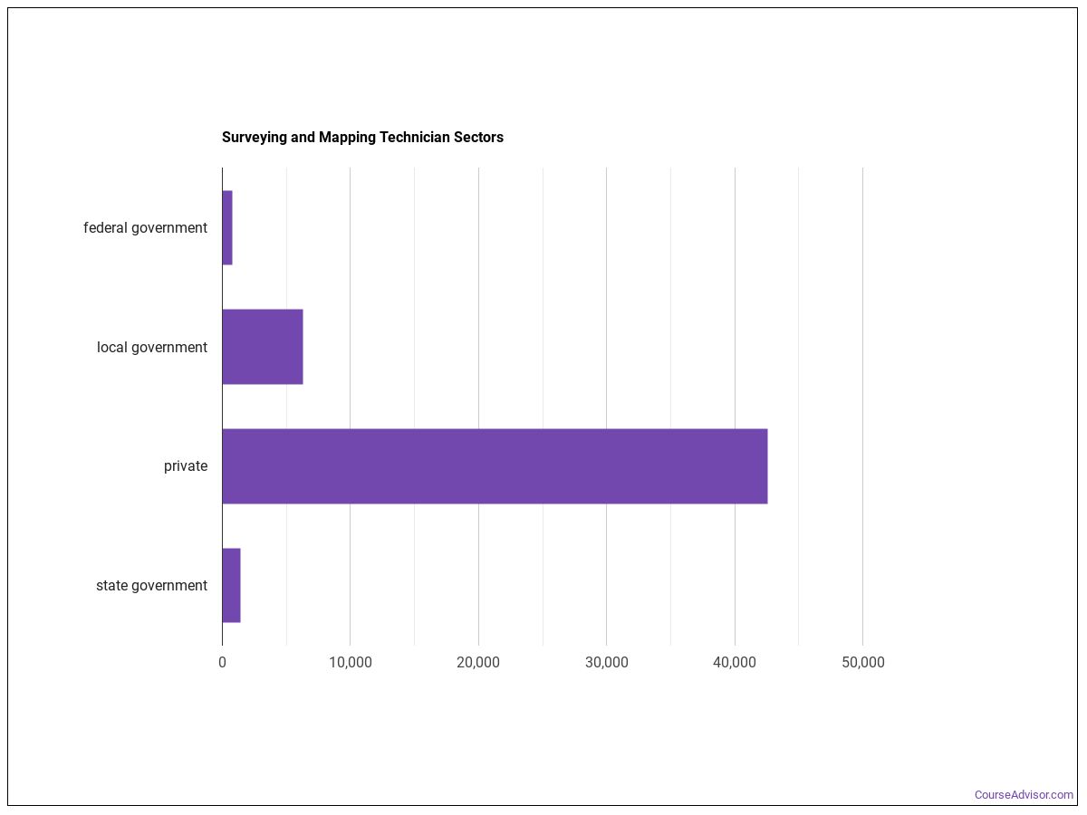
Industry Breakdown
Most surveying and mapping technicians are concentrated in the following sectors:
| Industry | Employment | Median annual wage |
|---|---|---|
| Professional, Scientific, and Technical Services | 38,010 | $49,260 |
| Administrative and Support and Waste Management and Remediation Services | 4,690 | $47,170 |
| Utilities | 2,230 | $76,970 |
| Construction | 2,060 | $55,940 |
| Management of Companies and Enterprises | 540 | $74,210 |
| Mining, Quarrying, and Oil and Gas Extraction | 430 | $61,690 |
| Information | 430 | $51,100 |
| Manufacturing | 180 | $49,010 |
Surveying and Mapping Technicians work in the following industries:

Software Surveying and Mapping Technicians Use
- Graphics or photo imaging software: Adobe Illustrator (hot technology)
- Graphics or photo imaging software: Adobe Photoshop (hot technology)
- Computer aided design CAD software: Autodesk AutoCAD (hot technology)
- Computer aided design CAD software: Autodesk AutoCAD Civil 3D (hot technology)
- Computer aided design CAD software: Bentley MicroStation (hot technology)
- Geographic information system: ESRI ArcGIS software (hot technology)
- Web platform development software: Hypertext markup language HTML (hot technology)
- Web platform development software: JavaScript (hot technology)
- Data base user interface and query software: Microsoft Access (hot technology)
- Spreadsheet software: Microsoft Excel (hot technology)
- Office suite software: Microsoft Office software (hot technology)
- Electronic mail software: Microsoft Outlook (hot technology)
Work Environment
The on-the-job environment of surveying and mapping technicians is shaped by the following characteristics:
- Importance of Being Exact or Accurate
- Face-to-Face Discussions with Individuals and Within Teams
- Telephone Conversations
- Freedom to Make Decisions
Getting Started in This Career
This career aligns with Medium Preparation Needed (Job Zone 3), reflecting the level of preparation typically expected.
Other Careers to Consider
Similar Occupations
- Geographic Information Systems Technologists and Technicians (Primary-Short)
- Data Scientists (Supplemental)
- Cartographers and Photogrammetrists (Primary-Short)
- Surveyors (Primary-Short)
- Geodetic Surveyors (Primary-Short)
- Civil Engineers (Supplemental)
- Mining and Geological Engineers, Including Mining Safety Engineers (Supplemental)
- Architectural and Civil Drafters (Primary-Long)
Where to Study
Future surveying and mapping technicians commonly pursue programs in:
Social Sciences
2 programs across 1 majors
Engineering Technologies and Engineering-Related Fields
1 programs across 1 majors
About the Data
Data on this page comes from the following authoritative sources:
- U.S. Bureau of Labor Statistics — Occupational Employment and Wage Statistics (OEWS) for employment and wage data by state and industry.
- BLS Employment Projections for total employment and growth forecasts.
- O*NET (Occupational Information Network) for skills, knowledge, tasks, work activities, work context, technology, and education-zone data.
SOC code: 17-3031.00 (Surveying and Mapping Technicians).
Course Advisor provides higher-education, college and university, degree, program, career, salary, and other helpful information to students, faculty, institutions, and other internet audiences. Presented information and data are subject to change. Inclusion on this website does not imply or represent a direct relationship with the company, school, or brand. Information, though believed correct at time of publication, may not be correct, and no warranty is provided. Contact the schools to verify any information before relying on it. Financial aid may be available for those who qualify. The displayed options may include sponsored or recommended results, not necessarily based on your preferences.
© Course Advisor – All Rights Reserved.