Geodetic Surveyors: Career Overview
Measure large areas of the Earth's surface using satellite observations, global navigation satellite systems (GNSS), light detection and ranging (LIDAR), or related sources.
Featured schools near , edit
The Daily Work of Geodetic Surveyors Perform?
The day-to-day responsibilities of geodetic surveyors include:
- Analyze control or survey data to ensure adherence to project specifications or land survey standards.
- Conduct surveys to determine exact positions, measurement of points, elevations, lines, areas, volumes, contours, or other features of land surfaces.
- Calculate the exact horizontal and vertical position of points on the Earth's surface.
- Maintain databases of geodetic and related information, including coordinate, descriptive, or quality assurance data.
- Verify the mathematical correctness of newly collected survey data.
- Compute horizontal and vertical coordinates of control networks, using direct leveling or other geodetic survey techniques, such as triangulation, trilateration, and traversing, to establish features of the Earth's surface.
- Plan or direct the work of geodetic surveying staff, providing technical consultation as needed.
- Assess the quality of control data to determine the need for additional survey data for engineering, construction, or other projects.
Skills and Knowledge
Effective geodetic surveyors combine a mix of skills and domain knowledge.
Top Skills
These are the skills that matter most in this role, rated on an importance scale of 0 to 5:
Core Knowledge
Other Geodetic Surveyors Job Titles
People in this occupation may also be known by titles such as:
- Aerial Photograph Interpreter
- Aerotriangulation Specialist
- Field Surveyor
- Geodesist
- Geodetic Advisor
- Geodetic Computator
- Geodetic Coordinator
- Geodetic Engineer
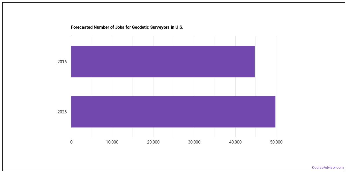
Employment and Demand
There are about 72,418 geodetic surveyors working in the United States today. Demand is forecast to decline by -3.5% over the projection horizon.
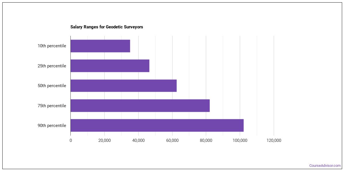
Salary for Geodetic Surveyors
| Statistic | Value |
|---|---|
| Annual median | $125,113 |
| Hourly median | $60.15 |
| 10th percentile | $78,214 |
| 25th percentile | $101,664 |
| 75th percentile | $148,563 |
| 90th percentile | $172,012 |
Wages vary widely based on experience, location, and industry.
How Much Do Geodetic Surveyors Make in Different U.S. States?
| State | Annual median salary |
|---|---|
| California | $103,790 |
| New Jersey | $93,260 |
| Washington | $88,340 |
| Oregon | $87,730 |
| South Dakota | $86,260 |
| Alaska | $85,520 |
| Delaware | $85,350 |
| Massachusetts | $84,260 |
| Nevada | $82,990 |
| Indiana | $81,010 |
| Maine | $80,740 |
| Hawaii | $79,730 |
| Montana | $79,230 |
| New York | $79,050 |
| North Dakota | $78,750 |
| Arizona | $78,480 |
| Illinois | $77,540 |
| Wyoming | $77,320 |
| Colorado | $77,050 |
| Wisconsin | $76,790 |
| Connecticut | $76,760 |
| Iowa | $76,720 |
| New Mexico | $75,190 |
| Tennessee | $74,690 |
| Idaho | $74,270 |
| Pennsylvania | $73,680 |
| Virginia | $73,380 |
| Kansas | $70,820 |
| Michigan | $69,990 |
| Vermont | $68,510 |
| North Carolina | $67,870 |
| Kentucky | $67,060 |
| New Hampshire | $66,750 |
| Nebraska | $66,020 |
| Ohio | $65,970 |
| Utah | $64,260 |
| Alabama | $63,700 |
| South Carolina | $62,160 |
| Maryland | $62,100 |
| Florida | $62,100 |
| West Virginia | $61,610 |
| Oklahoma | $60,870 |
| Georgia | $60,410 |
| Louisiana | $60,020 |
| District of Columbia | $59,860 |
| Missouri | $59,500 |
| Texas | $59,450 |
| Mississippi | $57,370 |
| Arkansas | $57,260 |
| Guam | $55,990 |
| Rhode Island | $52,000 |
| Minnesota | $46,610 |
| Puerto Rico | $40,780 |
Pay by U.S. Region
Pay for geodetic surveyors vary by region. These regions lead on median pay:
| Region | Median annual wage | Share of U.S. jobs | Location quotient |
|---|---|---|---|
| Far Western US | $96,962 | 11.5% | 0.77 |
| New England | $79,236 | 5.9% | 1.28 |
| Middle Atlantic | $76,529 | 9.6% | 0.72 |
| Rocky Mountains | $74,348 | 5.8% | 1.53 |
| Great Lakes | $73,826 | 10.7% | 0.77 |
| Southeast | $63,979 | 28.5% | 1.23 |
| Southwest | $62,625 | 18.9% | 1.52 |
| Plains States | $59,639 | 8.6% | 1.41 |
Where the Jobs Cluster
| Metro area | State | Median annual wage | Employment |
|---|---|---|---|
| Yuba City, CA | CA | $130,730 | 50 |
| Sacramento-Roseville-Folsom, CA | CA | $124,990 | 310 |
| San Francisco-Oakland-Fremont, CA | CA | $122,690 | 520 |
| Redding, CA | CA | $121,250 | 40 |
| Fresno, CA | CA | $115,620 | 130 |
| San Jose-Sunnyvale-Santa Clara, CA | CA | $110,450 | 190 |
| Salem, OR | OR | $105,000 | 50 |
| San Luis Obispo-Paso Robles, CA | CA | $104,480 | 50 |
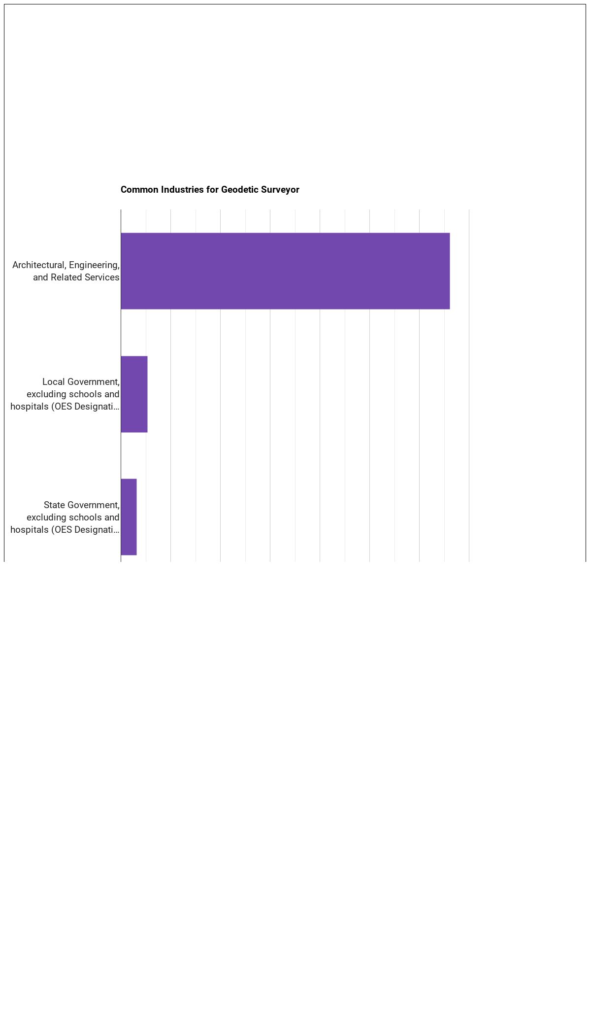
Industry Breakdown
Most geodetic surveyors work in these industries:
| Industry | Employment | Median annual wage |
|---|---|---|
| Professional, Scientific, and Technical Services | 40,270 | $67,870 |
| Construction | 5,050 | $72,800 |
| Mining, Quarrying, and Oil and Gas Extraction | 1,590 | $86,050 |
| Administrative and Support and Waste Management and Remediation Services | 690 | $75,840 |
| Utilities | 500 | $91,870 |
| Management of Companies and Enterprises | 240 | $82,820 |
| Transportation and Warehousing | 210 | $76,430 |
| Wholesale Trade | 60 | $63,660 |
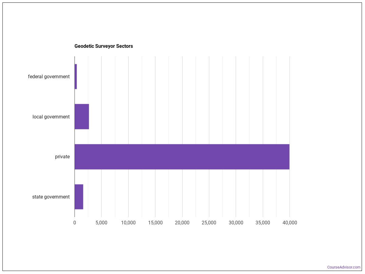
Below are examples of industries where geodetic surveyors work:
Tools and Technology
- Data base user interface and query software: Amazon Web Services AWS software (hot technology)
- Computer aided design CAD software: Autodesk AutoCAD (hot technology)
- Computer aided design CAD software: Bentley MicroStation (hot technology)
- Object or component oriented development software: C# (hot technology)
- Object or component oriented development software: C++ (hot technology)
- Geographic information system: ESRI ArcGIS software (hot technology)
- Web platform development software: Hypertext markup language HTML (hot technology)
- Operating system software: Linux (hot technology)
- Data base user interface and query software: Microsoft Access (hot technology)
- Spreadsheet software: Microsoft Excel (hot technology)
- Office suite software: Microsoft Office software (hot technology)
- Presentation software: Microsoft PowerPoint (hot technology)
What the Workplace Is Like
Daily working conditions for geodetic surveyors is shaped by the following characteristics:
- Importance of Being Exact or Accurate
- Telephone Conversations
- Face-to-Face Discussions with Individuals and Within Teams
- Freedom to Make Decisions
How to Become Geodetic Surveyors
Entry-level geodetic surveyors positions require a bachelor’s degree as the typical entry-level education. This career aligns with Considerable Preparation Needed (Job Zone 4), signaling the level of preparation typically expected.
Similar Occupations
Similar Occupations
- Geographic Information Systems Technologists and Technicians (Primary-Short)
- Data Scientists (Primary-Long)
- Cartographers and Photogrammetrists (Primary-Short)
- Surveyors (Primary-Short)
- Civil Engineers (Supplemental)
- Architectural and Civil Drafters (Supplemental)
- Civil Engineering Technologists and Technicians (Supplemental)
- Electrical and Electronic Engineering Technologists and Technicians (Supplemental)
Degree Programs
Aspiring geodetic surveyors commonly pursue programs in:
Engineering Technologies and Engineering-Related Fields
1 programs across 1 majors
Engineering
1 programs across 1 majors
References
This profile draws on the following authoritative sources:
- U.S. Bureau of Labor Statistics — Occupational Employment and Wage Statistics (OEWS) for employment and wage data by state and industry.
- BLS Employment Projections for total employment and growth forecasts.
- O*NET (Occupational Information Network) for skills, knowledge, tasks, work activities, work context, technology, and education-zone data.
SOC code: 17-1022.01 (Surveyors).
Course Advisor provides higher-education, college and university, degree, program, career, salary, and other helpful information to students, faculty, institutions, and other internet audiences. Presented information and data are subject to change. Inclusion on this website does not imply or represent a direct relationship with the company, school, or brand. Information, though believed correct at time of publication, may not be correct, and no warranty is provided. Contact the schools to verify any information before relying on it. Financial aid may be available for those who qualify. The displayed options may include sponsored or recommended results, not necessarily based on your preferences.
© Course Advisor – All Rights Reserved.