Cartographers and Photogrammetrists: Job Description
Research, study, and prepare maps and other spatial data in digital or graphic form for one or more purposes, such as legal, social, political, educational, and design purposes. May work with Geographic Information Systems (GIS). May design and evaluate algorithms, data structures, and user interfaces for GIS and mapping systems. May collect, analyze, and interpret geographic information provided by geodetic surveys, aerial photographs, and satellite data.
Featured schools near , edit
What Tasks Do Cartographers and Photogrammetrists Do?
Typical responsibilities of cartographers and photogrammetrists span:
- Compile data required for map preparation, including aerial photographs, survey notes, records, reports, and original maps.
- Delineate aerial photographic detail, such as control points, hydrography, topography, and cultural features, using precision stereoplotting apparatus or drafting instruments.
- Prepare and alter trace maps, charts, tables, detailed drawings, and three-dimensional optical models of terrain using stereoscopic plotting and computer graphics equipment.
- Study legal records to establish boundaries of local, national, and international properties.
- Inspect final compositions to ensure completeness and accuracy.
- Revise existing maps and charts, making all necessary corrections and adjustments.
- Identify, scale, and orient geodetic points, elevations, and other planimetric or topographic features, applying standard mathematical formulas.
- Collect information about specific features of the Earth, using aerial photography and other digital remote sensing techniques.
Key Skills and Knowledge
Top cartographers and photogrammetrists combine a mix of skills and domain knowledge.
Key Skills
The abilities most important for this role, rated on an importance scale of 0 to 5:
Knowledge Areas
Related Job Titles
This career also goes by job titles like:
- Aerial Photogrammetrist
- Cadastral Mapper
- Cartographer
- Cartographic Designer
- Cartographic Drafter
- Cartography Technician
- Data Mapper
- Digital Cartographer
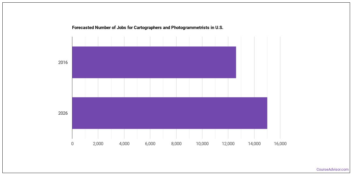
Employment and Demand
The U.S. employs around 58,033 cartographers and photogrammetrists working in the United States today. This occupation is expected to decline by -4.8% over the projection horizon.
Cartographers and Photogrammetrists Pay
| Statistic | Value |
|---|---|
| Annual median | $56,771 |
| Hourly median | $27.29 |
| 10th percentile | $32,419 |
| 25th percentile | $44,595 |
| 75th percentile | $68,948 |
| 90th percentile | $81,124 |
Compensation varies based on experience, location, and industry.

Pay by State
| State | Annual median salary |
|---|---|
| District of Columbia | $117,960 |
| California | $106,610 |
| Connecticut | $94,000 |
| Washington | $93,030 |
| New York | $93,030 |
| Nevada | $91,550 |
| Oklahoma | $90,460 |
| Massachusetts | $89,250 |
| Hawaii | $88,200 |
| Minnesota | $86,810 |
| New Jersey | $85,220 |
| Oregon | $82,810 |
| Maryland | $82,760 |
| North Dakota | $82,760 |
| Maine | $81,620 |
| Ohio | $80,290 |
| Alaska | $79,220 |
| Colorado | $78,030 |
| Virginia | $77,930 |
| Iowa | $77,630 |
| Missouri | $77,380 |
| Wisconsin | $77,100 |
| North Carolina | $76,680 |
| Nebraska | $75,360 |
| Tennessee | $74,990 |
| Arizona | $74,970 |
| Mississippi | $74,520 |
| South Dakota | $72,640 |
| Michigan | $72,280 |
| Texas | $71,970 |
| Illinois | $71,330 |
| New Hampshire | $70,190 |
| Florida | $70,120 |
| Alabama | $70,110 |
| Pennsylvania | $69,790 |
| Idaho | $69,390 |
| Utah | $65,250 |
| Kentucky | $64,180 |
| Wyoming | $63,760 |
| Montana | $60,920 |
| South Carolina | $60,170 |
| Georgia | $55,150 |
| West Virginia | $54,870 |
| Kansas | $50,500 |
Top-Paying U.S. Regions
Pay for cartographers and photogrammetrists shift depending on where you work. These regions lead on median pay:
| Region | Median annual wage | Share of U.S. jobs | Location quotient |
|---|---|---|---|
| Far Western US | $95,732 | 21.3% | 1.91 |
| Middle Atlantic | $85,271 | 8.1% | 1.46 |
| New England | $80,441 | 2.4% | 1.15 |
| Great Lakes | $77,111 | 6.0% | 0.71 |
| Rocky Mountains | $75,273 | 14.5% | 4.96 |
| Southwest | $72,992 | 15.9% | 1.33 |
| Plains States | $70,486 | 7.7% | 1.87 |
| Southeast | $69,908 | 24.0% | 1.37 |
Where the Jobs Cluster
| Metro area | State | Median annual wage | Employment |
|---|---|---|---|
| San Jose-Sunnyvale-Santa Clara, CA | CA | $133,730 | 30 |
| Sacramento-Roseville-Folsom, CA | CA | $128,410 | 180 |
| San Francisco-Oakland-Fremont, CA | CA | $122,740 | 170 |
| Los Angeles-Long Beach-Anaheim, CA | CA | $106,100 | 230 |
| Seattle-Tacoma-Bellevue, WA | WA | $103,240 | 310 |
| Dayton-Kettering-Beavercreek, OH | OH | $103,140 | 40 |
| Salem, OR | OR | $99,400 | 50 |
| Washington-Arlington-Alexandria, DC-VA-MD-WV | DC | $96,270 | 690 |
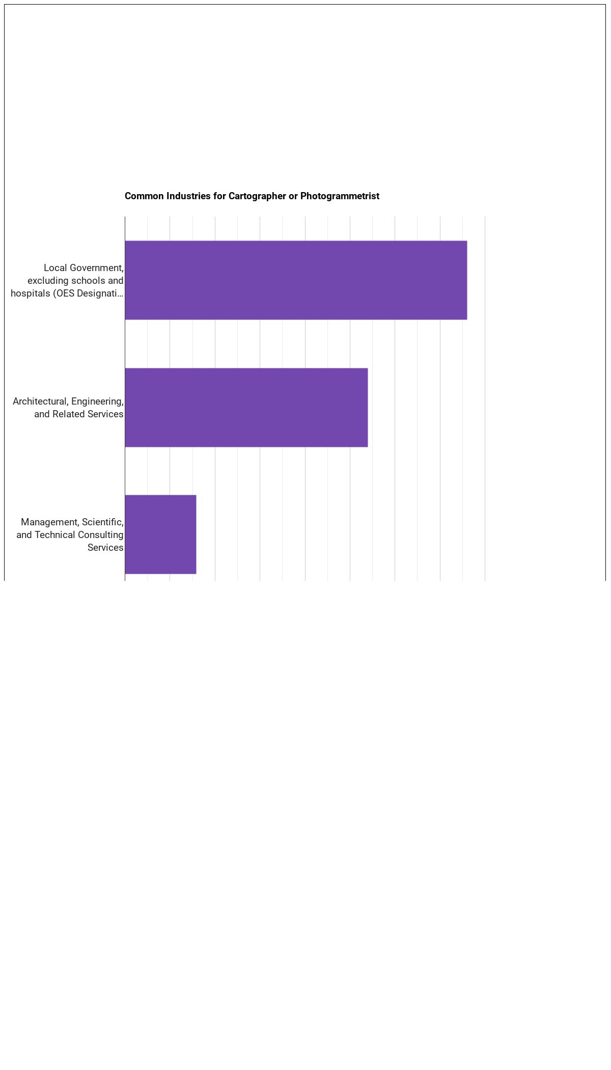
Top Industries Employing Cartographers and Photogrammetrists
The largest employers of cartographers and photogrammetrists work in these industries:
| Industry | Employment | Median annual wage |
|---|---|---|
| Professional, Scientific, and Technical Services | 4,340 | $71,490 |
| Utilities | 760 | $96,000 |
| Management of Companies and Enterprises | 460 | $92,510 |
| Information | 140 | $72,430 |
| Educational Services | 130 | $69,150 |
| Mining, Quarrying, and Oil and Gas Extraction | 100 | $114,670 |
| Other Services (except Public Administration) | 90 | $68,800 |
| Manufacturing | 70 | $80,610 |
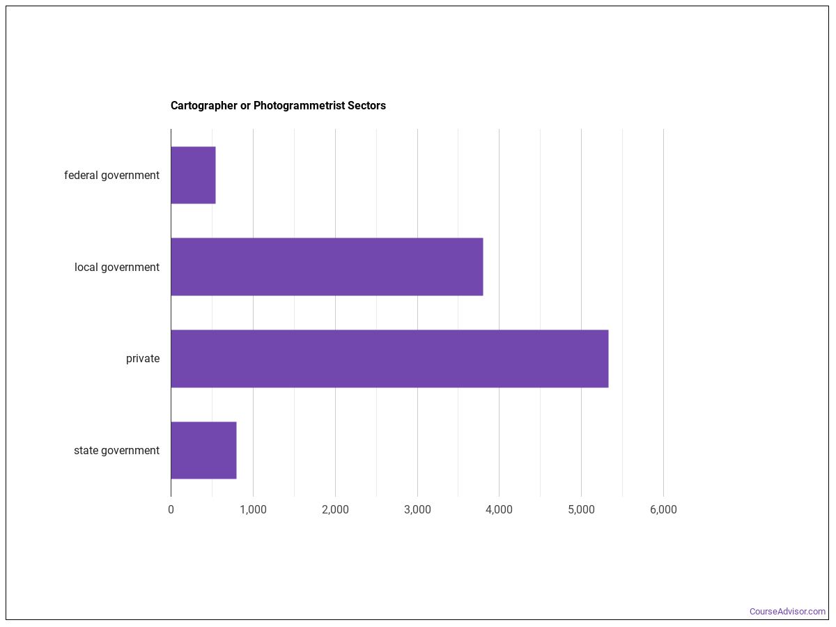
Below are examples of industries where cartographers and photogrammetrists work:
Tech Stack
- Document management software: Adobe Acrobat (hot technology)
- Graphics or photo imaging software: Adobe Creative Cloud software (hot technology)
- Graphics or photo imaging software: Adobe Illustrator (hot technology)
- Desktop publishing software: Adobe InDesign (hot technology)
- Graphics or photo imaging software: Adobe Photoshop (hot technology)
- Computer aided design CAD software: Autodesk AutoCAD (hot technology)
- Computer aided design CAD software: Bentley MicroStation (hot technology)
- Development environment software: C (hot technology)
- Geographic information system: ESRI ArcGIS software (hot technology)
- Enterprise application integration software: Extensible markup language XML (hot technology)
- Web platform development software: JavaScript Object Notation JSON (hot technology)
- Data base user interface and query software: Microsoft Access (hot technology)
Work Environment
Daily working conditions for cartographers and photogrammetrists reflects the following characteristics:
- Indoors, Environmentally Controlled
- Importance of Being Exact or Accurate
- Spend Time Sitting
- Telephone Conversations
How to Become Cartographers and Photogrammetrists
Entry-level cartographers and photogrammetrists positions require some college, no degree as the typical entry-level education. The role falls in Considerable Preparation Needed (Job Zone 4), signaling the level of preparation typically expected.
Other Careers to Consider
Similar Occupations
- Database Architects (Supplemental)
- Data Warehousing Specialists (Supplemental)
- Software Developers (Supplemental)
- Geographic Information Systems Technologists and Technicians (Primary-Short)
- Data Scientists (Primary-Long)
- Surveyors (Primary-Short)
- Geodetic Surveyors (Primary-Short)
- Architectural and Civil Drafters (Primary-Long)
Where to Study
Students preparing for cartographers and photogrammetrists often complete programs in:
Social Sciences
1 programs across 1 majors
Engineering Technologies and Engineering-Related Fields
1 programs across 1 majors
Engineering
1 programs across 1 majors
Homeland Security, Law Enforcement, Firefighting and Related Protective Services
1 programs across 1 majors
Military Technologies and Applied Sciences
1 programs across 1 majors
References
Data on this page comes from the following authoritative sources:
- U.S. Bureau of Labor Statistics — Occupational Employment and Wage Statistics (OEWS) for employment and wage data by state and industry.
- BLS Employment Projections for total employment and growth forecasts.
- O*NET (Occupational Information Network) for skills, knowledge, tasks, work activities, work context, technology, and education-zone data.
SOC code: 17-1021.00 (Cartographers and Photogrammetrists).
Course Advisor provides higher-education, college and university, degree, program, career, salary, and other helpful information to students, faculty, institutions, and other internet audiences. Presented information and data are subject to change. Inclusion on this website does not imply or represent a direct relationship with the company, school, or brand. Information, though believed correct at time of publication, may not be correct, and no warranty is provided. Contact the schools to verify any information before relying on it. Financial aid may be available for those who qualify. The displayed options may include sponsored or recommended results, not necessarily based on your preferences.
© Course Advisor – All Rights Reserved.