Cartographers and Photogrammetrists in Wisconsin
Considering working as a Cartographers and Photogrammetrists in Wisconsin? Below are the key facts. Research, study, and prepare maps and other spatial data in digital or graphic form for one or more purposes, such as legal, social, political, educational, and design purposes. May work with Geographic Information Systems (GIS). May design and evaluate algorithms, data structures, and user interfaces for GIS and mapping systems. May collect, analyze, and interpret geographic information provided by geodetic surveys, aerial photographs, and satellite data.
What do Cartographers and Photogrammetrists Make in Wisconsin?
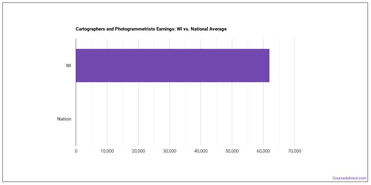
For cartographers and photogrammetrists working in Wisconsin, the typical annual salary is $77,100 per year (or about $37.07/hour).Pay can range from $61,970 at the 10th percentile to $106,020 at the 90th percentile.
| Wage Statistic | Annual | Hourly |
|---|---|---|
| 10th percentile | $61,970 | $29.79 |
| 25th percentile | $66,880 | $32.16 |
| Median (50th) | $77,100 | $37.07 |
| 75th percentile | $92,260 | $44.36 |
| 90th percentile | $106,020 | $50.97 |

Location quotient — how concentrated this career is in Wisconsin relative to the national average — is 0.85, meaning fewer cartographers and photogrammetrists per worker than the national average.
National Wage Comparison
Nationally, cartographers and photogrammetrists earn a median of $56,771 per year ($27.29/hour), exceeding the Wisconsin median.
Employment Outlook
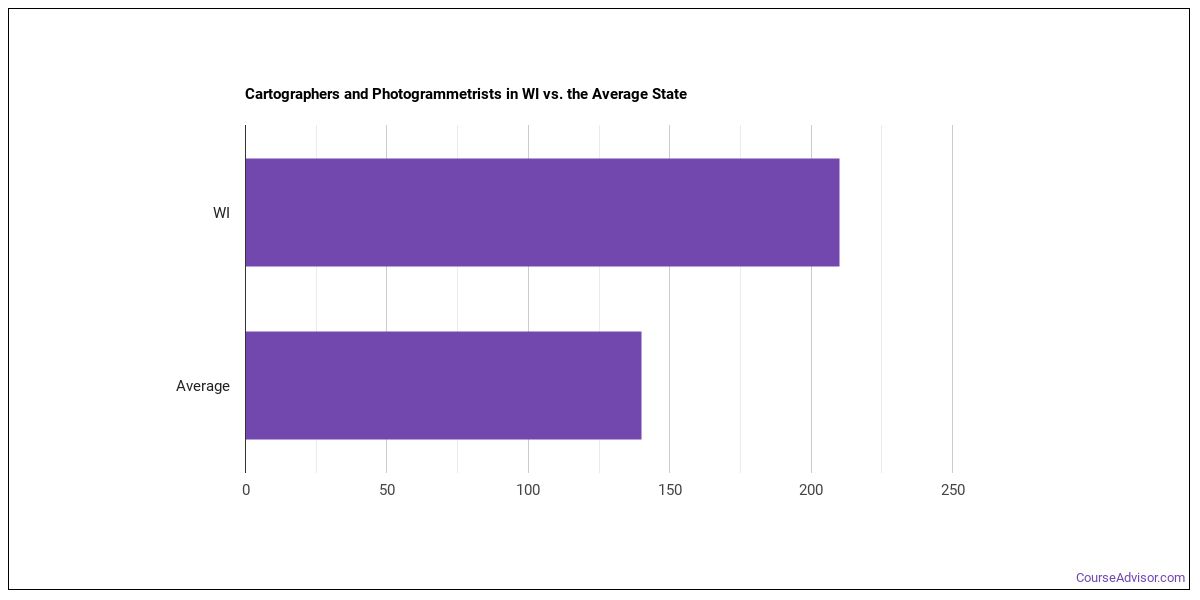
Nationally, total employment in this occupation is 58,033 cartographers and photogrammetrists across the United States. In Wisconsin alone, around 210 people work in this role. That puts the state above the typical state, which employs around 170 cartographers and photogrammetrists.

Top Wisconsin Metros for Cartographers and Photogrammetrists
The metro areas below employ the most cartographers and photogrammetrists in Wisconsin.
| Metro Area | Number Employed | Annual Median Salary |
|---|---|---|
| Madison, WI | 50 | $96,100 |
| Milwaukee-Waukesha, WI | 40 | $81,100 |
Top States for Cartographers and Photogrammetrists Employment
These states have the highest employment of cartographers and photogrammetrists work.
| State | Number Employed |
|---|---|
| Texas | 1,550 |
| Colorado | 1,380 |
| California | 1,070 |
| Virginia | 750 |
| Washington | 670 |
| Oregon | 600 |
| North Carolina | 600 |
| Georgia | 590 |
| Maryland | 550 |
| Florida | 500 |
| Arizona | 360 |
| Ohio | 320 |
| Kansas | 260 |
| Nevada | 220 |
| Missouri | 220 |
| Michigan | 210 |
| Wisconsin | 210 |
| Utah | 200 |
| New York | 190 |
| South Dakota | 170 |
Highest-Paying States for Cartographers and Photogrammetrists
Where cartographers and photogrammetrists earn the most: cartographers and photogrammetrists.
| State | Annual Median Salary |
|---|---|
| District of Columbia | $117,960 |
| California | $106,610 |
| Connecticut | $94,000 |
| Washington | $93,030 |
| New York | $93,030 |
| Nevada | $91,550 |
| Oklahoma | $90,460 |
| Massachusetts | $89,250 |
| Hawaii | $88,200 |
| Minnesota | $86,810 |
Skills
The most important cartographers and photogrammetrists skills, rated on an importance scale of 0 to 5:
Knowledge Areas
Important knowledge areas for this occupation, rated on an importance scale of 0 to 5:
Abilities
The abilities that matter most for cartographers and photogrammetrists, rated on an importance scale of 0 to 5:
Daily Tasks
Day-to-day, cartographers and photogrammetrists typically:
- Compile data required for map preparation, including aerial photographs, survey notes, records, reports, and original maps.
- Delineate aerial photographic detail, such as control points, hydrography, topography, and cultural features, using precision stereoplotting apparatus or drafting instruments.
- Prepare and alter trace maps, charts, tables, detailed drawings, and three-dimensional optical models of terrain using stereoscopic plotting and computer graphics equipment.
- Study legal records to establish boundaries of local, national, and international properties.
- Inspect final compositions to ensure completeness and accuracy.
- Revise existing maps and charts, making all necessary corrections and adjustments.
- Identify, scale, and orient geodetic points, elevations, and other planimetric or topographic features, applying standard mathematical formulas.
- Collect information about specific features of the Earth, using aerial photography and other digital remote sensing techniques.
- Examine and analyze data from ground surveys, reports, aerial photographs, and satellite images to prepare topographic maps, aerial-photograph mosaics, and related charts.
- Build and update digital databases.
- Determine map content and layout, as well as production specifications such as scale, size, projection, and colors, and direct production to ensure that specifications are followed.
- Determine guidelines that specify which source material is acceptable for use.
Work Activities
- Getting Information
- Working with Computers
- Evaluating Information to Determine Compliance with Standards
- Making Decisions and Solving Problems
- Updating and Using Relevant Knowledge
- Identifying Objects, Actions, and Events
- Documenting/Recording Information
- Processing Information
- Communicating with People Outside the Organization
- Analyzing Data or Information
- Communicating with Supervisors, Peers, or Subordinates
- Thinking Creatively
Tools & Technology
Common tools and software used in this occupation include: Hot technologies: Adobe Acrobat, Adobe Creative Cloud software, Adobe Illustrator In-demand technologies: ESRI ArcGIS software
What Major Will Prepare You For This Career?
Related college programs include:
- Geography & Cartography
- Engineering-Related Technologies
- Surveying Engineering
- Security Science and Technology
- Intelligence & Command Operations
Featured schools near , edit
Related Careers
Other careers like cartographers and photogrammetrists include:
- Database Architects
- Data Warehousing Specialists
- Software Developers
- Geographic Information Systems Technologists and Technicians
- Data Scientists
- Surveyors
Also Known As
Aerial Photogrammetrist, Cadastral Mapper, Cartographer, Cartographic Designer, Cartographic Drafter, Cartography Technician, Data Mapper, Digital Cartographer, Field Map Editor, Geospatial Specialist, Imagery Analyst, LIDAR Technician (Light Detection and Ranging Technician), Map Editor, Map Maker, Mapper.
References
- U.S. Bureau of Labor Statistics, Occupational Employment and Wage Statistics — https://www.bls.gov/oes/
- O*NET Online — https://www.onetonline.org/
- BLS Employment Projections — https://www.bls.gov/emp/
- O*NET-SOC code: 17-1021.00
Course Advisor provides higher-education, college and university, degree, program, career, salary, and other helpful information to students, faculty, institutions, and other internet audiences. Presented information and data are subject to change. Inclusion on this website does not imply or represent a direct relationship with the company, school, or brand. Information, though believed correct at time of publication, may not be correct, and no warranty is provided. Contact the schools to verify any information before relying on it. Financial aid may be available for those who qualify. The displayed options may include sponsored or recommended results, not necessarily based on your preferences.
© Course Advisor – All Rights Reserved.