All About Geodetic Surveyors
Position Description Measure large areas of the Earth’s surface using satellite observations, global navigation satellite systems (GNSS), light detection and ranging (LIDAR), or related sources.
A Day in the Life of a Geodetic Surveyor
- Analyze control or survey data to ensure adherence to project specifications or land survey standards.
- Read current literature, talk with colleagues, continue education, or participate in professional organizations or conferences to keep abreast of developments in technology, equipment, or systems.
- Assess the quality of control data to determine the need for additional survey data for engineering, construction, or other projects.
- Conduct surveys to determine exact positions, measurement of points, elevations, lines, areas, volumes, contours, or other features of land surfaces.
- Compute, retrace, or adjust existing surveys of features such as highway alignments, property boundaries, utilities, control and other surveys to match the ground elevation-dependent grids, geodetic grids, or property boundaries and to ensure accuracy and continuity of data used in engineering, surveying, or construction projects.
- Determine orientation of tracts of land, including position, boundaries, size, and shape, using theodolites, electronic distance-measuring equipment, satellite-based positioning equipment, land information systems, or other geodetic survey equipment.
Featured schools near , edit
Geodetic Surveyor Required Skills
These are the skills Geodetic Surveyors say are the most useful in their careers:
Mathematics: Using mathematics to solve problems.
Critical Thinking: Using logic and reasoning to identify the strengths and weaknesses of alternative solutions, conclusions or approaches to problems.
Reading Comprehension: Understanding written sentences and paragraphs in work related documents.
Active Listening: Giving full attention to what other people are saying, taking time to understand the points being made, asking questions as appropriate, and not interrupting at inappropriate times.
Complex Problem Solving: Identifying complex problems and reviewing related information to develop and evaluate options and implement solutions.
Judgment and Decision Making: Considering the relative costs and benefits of potential actions to choose the most appropriate one.
Other Geodetic Surveyor Job Titles
- Geodetic Computator
- Measurement and Sensing Technician
- Geodetic Surveyor Technologist
- Remote Advisor
- Survey Director
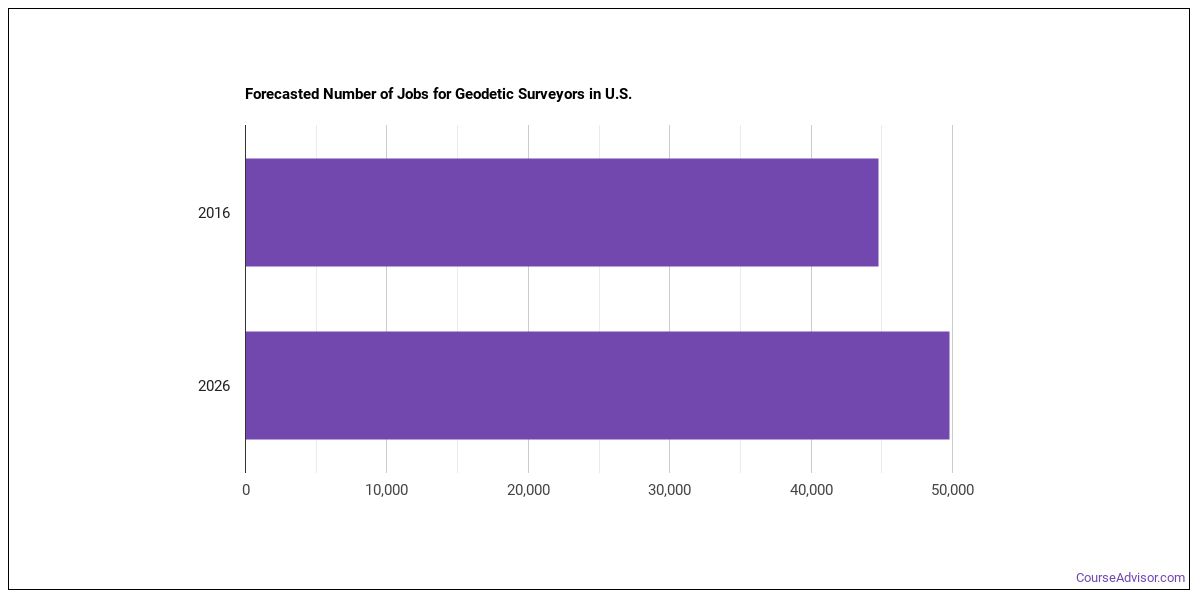
Is There Job Demand for Geodetic Surveyors?
There were about 44,800 jobs for Geodetic Surveyor in 2016 (in the United States). New jobs are being produced at a rate of 11.2% which is above the national average. The Bureau of Labor Statistics predicts 5,000 new jobs for Geodetic Surveyor by 2026. The BLS estimates 3,800 yearly job openings in this field.
The states with the most job growth for Geodetic Surveyor are Utah, Florida, and North Dakota. Watch out if you plan on working in Vermont, Washington, or Maine. These states have the worst job growth for this type of profession.
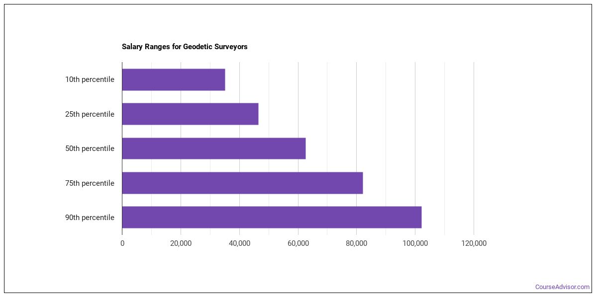
Do Geodetic Surveyors Make A Lot Of Money?
The salary for Geodetic Surveyors ranges between about $35,160 and $102,220 a year.
Geodetic Surveyors who work in California, Washington, or Nevada, make the highest salaries.
How much do Geodetic Surveyors make in different U.S. states?
| State | Annual Mean Salary |
|---|---|
| Alabama | $56,010 |
| Alaska | $79,940 |
| Arizona | $62,050 |
| Arkansas | $48,880 |
| California | $91,010 |
| Colorado | $66,010 |
| Connecticut | $70,810 |
| Delaware | $73,110 |
| Florida | $57,930 |
| Georgia | $59,500 |
| Hawaii | $65,880 |
| Idaho | $65,550 |
| Illinois | $72,540 |
| Indiana | $60,890 |
| Iowa | $65,250 |
| Kansas | $58,420 |
| Kentucky | $56,510 |
| Louisiana | $62,810 |
| Maine | $59,360 |
| Maryland | $65,220 |
| Massachusetts | $66,000 |
| Michigan | $58,850 |
| Minnesota | $65,950 |
| Mississippi | $46,660 |
| Missouri | $59,980 |
| Montana | $63,020 |
| Nebraska | $54,750 |
| Nevada | $80,520 |
| New Hampshire | $63,710 |
| New Jersey | $70,120 |
| New Mexico | $74,470 |
| New York | $77,660 |
| North Carolina | $70,460 |
| North Dakota | $75,360 |
| Ohio | $62,520 |
| Oklahoma | $54,130 |
| Oregon | $68,130 |
| Pennsylvania | $62,400 |
| Rhode Island | $60,070 |
| South Carolina | $49,570 |
| South Dakota | $67,970 |
| Tennessee | $49,280 |
| Texas | $59,980 |
| Utah | $69,150 |
| Vermont | $51,890 |
| Virginia | $70,230 |
| Washington | $85,860 |
| West Virginia | $65,750 |
| Wisconsin | $62,820 |
| Wyoming | $66,160 |
Tools & Technologies Used by Geodetic Surveyors
Below is a list of the types of tools and technologies that Geodetic Surveyors may use on a daily basis:
- Microsoft Excel
- Microsoft Word
- Microsoft Office
- Hypertext markup language HTML
- Web browser software
- Email software
- Autodesk AutoCAD
- Geographic information system GIS software
- Bentley Microstation
- ESRI ArcView
- ESRI ArcGIS software
- Virtual reality modeling language VRML software
- Trimble Terramodel
- Traverse PC
- Autodesk CAiCE Visual Transportation
- SiteComp Survey
- QuickCogo
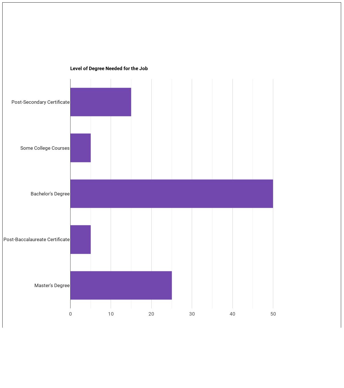
Becoming a Geodetic Surveyor
Are there Geodetic Surveyors education requirements?
What work experience do I need to become a Geodetic Surveyor?

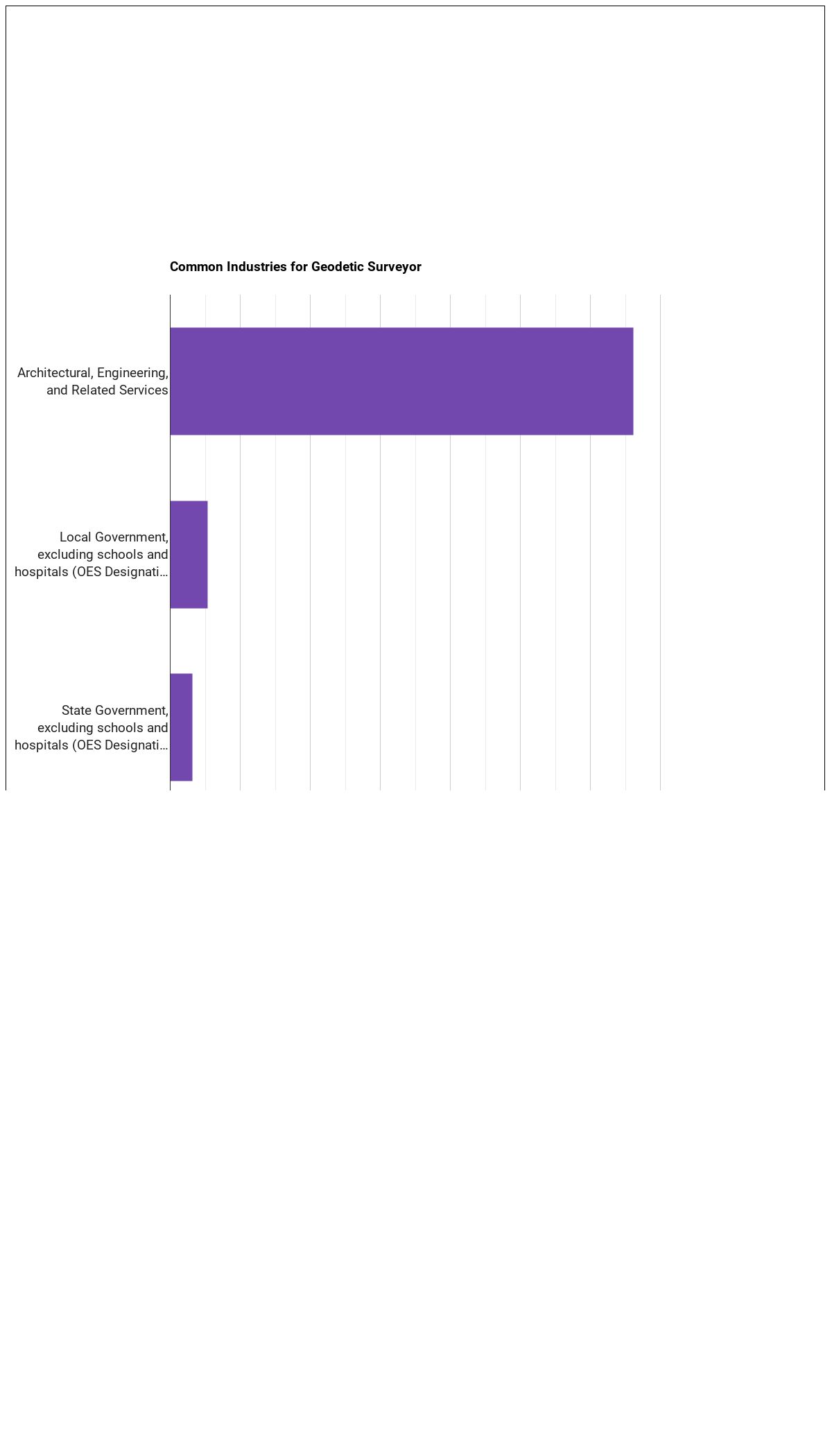
Where Geodetic Surveyors Work
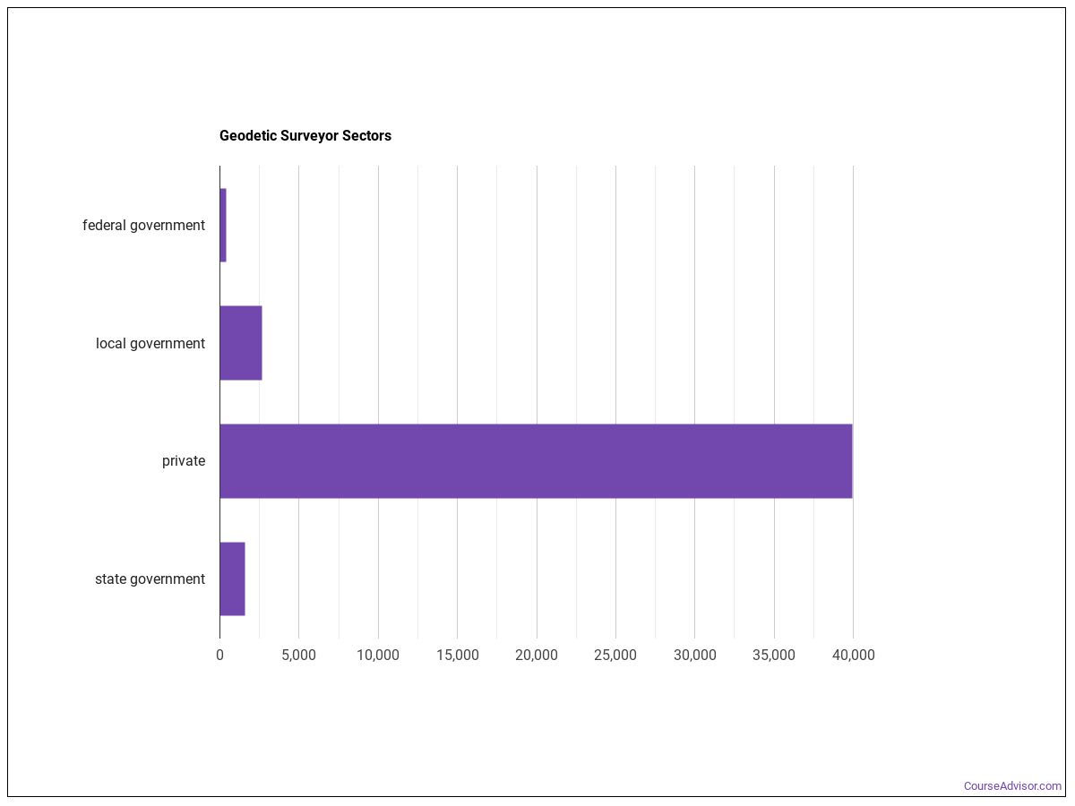
The table below shows the approximate number of Geodetic Surveyors employed by various industries.
Similar Careers
Those interested in being a Geodetic Surveyor may also be interested in:
Those who work as a Geodetic Surveyor sometimes switch careers to one of these choices:
References:
Image Credit: Mike1979 Russia via Creative Commons Attribution-Share Alike 3.0 Unported
More about our data sources and methodologies.
Featured Schools
 Request Info
|
Southern New Hampshire University You have goals. Southern New Hampshire University can help you get there. Whether you need a bachelor's degree to get into a career or want a master's degree to move up in your current career, SNHU has an online program for you. Find your degree from over 200 online programs. Learn More > |
Course Advisor provides higher-education, college and university, degree, program, career, salary, and other helpful information to students, faculty, institutions, and other internet audiences. Presented information and data are subject to change. Inclusion on this website does not imply or represent a direct relationship with the company, school, or brand. Information, though believed correct at time of publication, may not be correct, and no warranty is provided. Contact the schools to verify any information before relying on it. Financial aid may be available for those who qualify. The displayed options may include sponsored or recommended results, not necessarily based on your preferences.
© Course Advisor – All Rights Reserved.