What is a Geophysical Data Technician?
Example of Geophysical Data Technician Job Measure, record, or evaluate geological data, using sonic, electronic, electrical, seismic, or gravity-measuring instruments to prospect for oil or gas. May collect or evaluate core samples or cuttings.
Life As a Geophysical Data Technician: What Do They Do?
- Record readings in order to compile data used in prospecting for oil or gas.
- Plan and direct activities of workers who operate equipment to collect data.
- Operate or adjust equipment or apparatus used to obtain geological data.
- Read and study reports in order to compile information and data for geological and geophysical prospecting.
- Collect samples or cuttings, using equipment or hand tools.
- Create photographic recordings of information, using equipment.
Featured schools near , edit
Geophysical Data Technician Required Skills
Below is a list of the skills most Geophysical Data Technicians say are important on the job.
Reading Comprehension: Understanding written sentences and paragraphs in work related documents.
Critical Thinking: Using logic and reasoning to identify the strengths and weaknesses of alternative solutions, conclusions or approaches to problems.
Active Listening: Giving full attention to what other people are saying, taking time to understand the points being made, asking questions as appropriate, and not interrupting at inappropriate times.
Speaking: Talking to others to convey information effectively.
Writing: Communicating effectively in writing as appropriate for the needs of the audience.
Time Management: Managing one’s own time and the time of others.
Types of Geophysical Data Technician
- Meter Operator
- Field Observer
- Field Scout
- Directional Drill Locator
- Electrical Prospecting Supervisor
Geophysical Data Technician Job Outlook
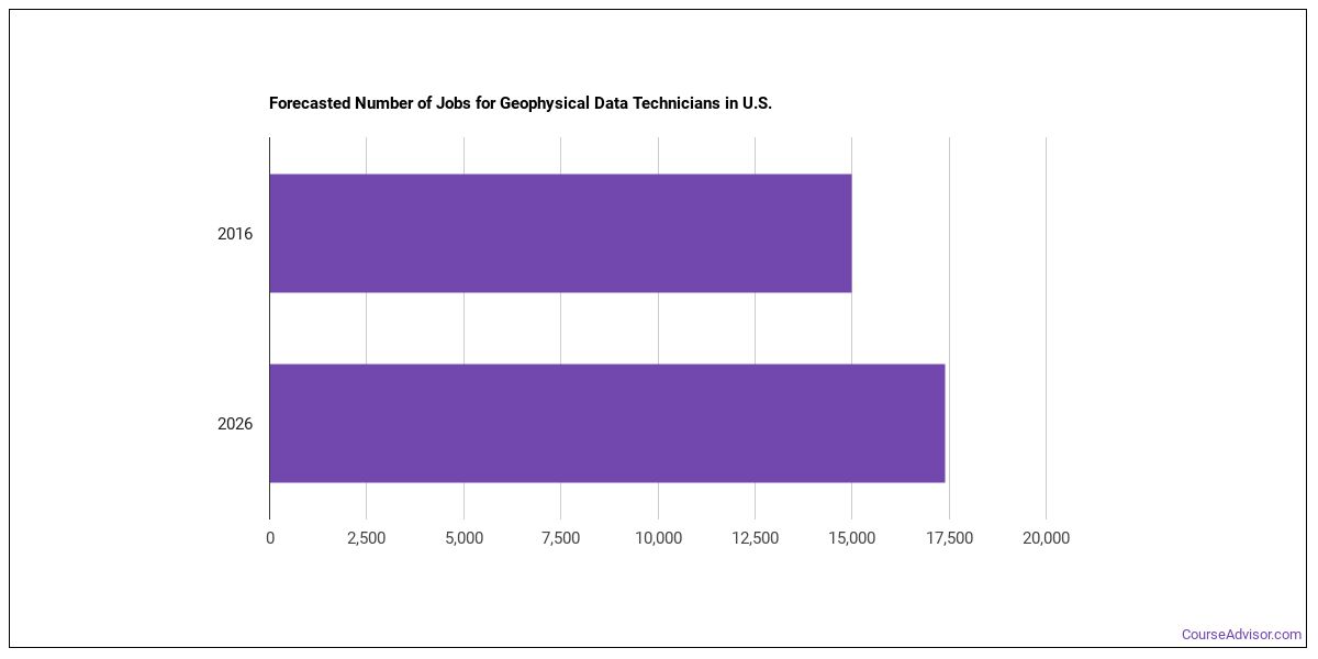
In 2016, there was an estimated number of 15,000 jobs in the United States for Geophysical Data Technician. New jobs are being produced at a rate of 16% which is above the national average. The Bureau of Labor Statistics predicts 2,400 new jobs for Geophysical Data Technician by 2026. Due to new job openings and attrition, there will be an average of 1,900 job openings in this field each year.
The states with the most job growth for Geophysical Data Technician are Wyoming, North Carolina, and Utah. Watch out if you plan on working in Kentucky, West Virginia, or New Hampshire. These states have the worst job growth for this type of profession.
Do Geophysical Data Technicians Make A Lot Of Money?
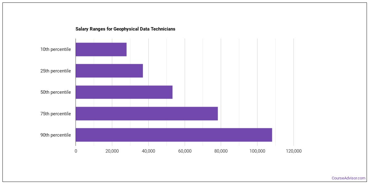
The average yearly salary of a Geophysical Data Technician ranges between $28,020 and $108,110.
Geophysical Data Technicians who work in New Mexico, Alaska, or Kentucky, make the highest salaries.
How much do Geophysical Data Technicians make in each U.S. state?
| State | Annual Mean Salary |
|---|---|
| Alabama | $52,180 |
| Alaska | $76,650 |
| Arizona | $45,350 |
| Arkansas | $45,670 |
| California | $52,900 |
| Florida | $39,930 |
| Georgia | $64,110 |
| Idaho | $40,750 |
| Illinois | $39,500 |
| Indiana | $60,210 |
| Kansas | $48,530 |
| Kentucky | $64,540 |
| Louisiana | $64,640 |
| Maryland | $50,230 |
| Massachusetts | $62,840 |
| Michigan | $50,010 |
| Minnesota | $55,610 |
| Mississippi | $52,570 |
| Missouri | $49,620 |
| Montana | $61,730 |
| Nebraska | $66,470 |
| Nevada | $56,330 |
| New Mexico | $90,010 |
| New York | $54,920 |
| North Dakota | $60,050 |
| Ohio | $49,660 |
| Oklahoma | $55,580 |
| Pennsylvania | $49,190 |
| South Carolina | $51,610 |
| Tennessee | $54,600 |
| Texas | $66,760 |
| Utah | $51,400 |
| Virginia | $46,460 |
| Washington | $53,840 |
| West Virginia | $57,350 |
| Wyoming | $59,410 |
What Tools & Technology do Geophysical Data Technicians Use?
Although they’re not necessarily needed for all jobs, the following technologies are used by many Geophysical Data Technicians:
- Microsoft Excel
- Microsoft Word
- Microsoft Office
- Microsoft PowerPoint
- Microsoft Access
- Autodesk AutoCAD
- Database software
- Adobe Systems Adobe Illustrator
- Geographic information system GIS software
- Corel CorelDraw Graphics Suite
- SAP BusinessObjects Crystal Reports
- Leica Geosystems ERDAS IMAGINE
- ESRI ArcGIS software
- Golden Software Surfer
- Geographic resources analysis support system GRASS
- Landmark GeoGraphix
- IHS PETRA
- Clark Labs IDRISI Andes
- Seismic Micro-Technology KINGDOM
- Parallel Geoscience SPW
Becoming a Geophysical Data Technician
What kind of Geophysical Data Technician requirements are there?
How Long Does it Take to Become a Geophysical Data Technician?
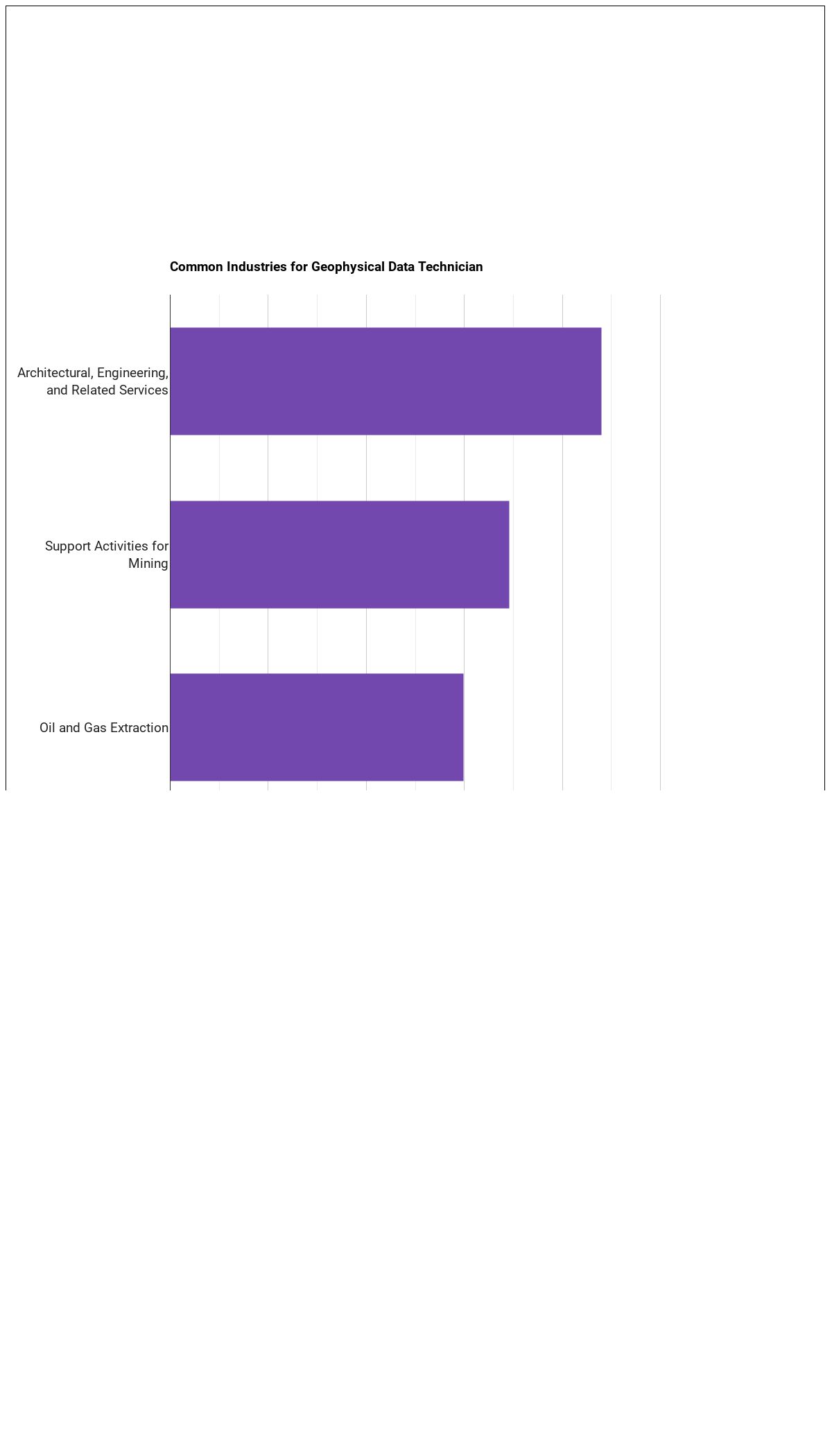
Where do Geophysical Data Technicians Work?
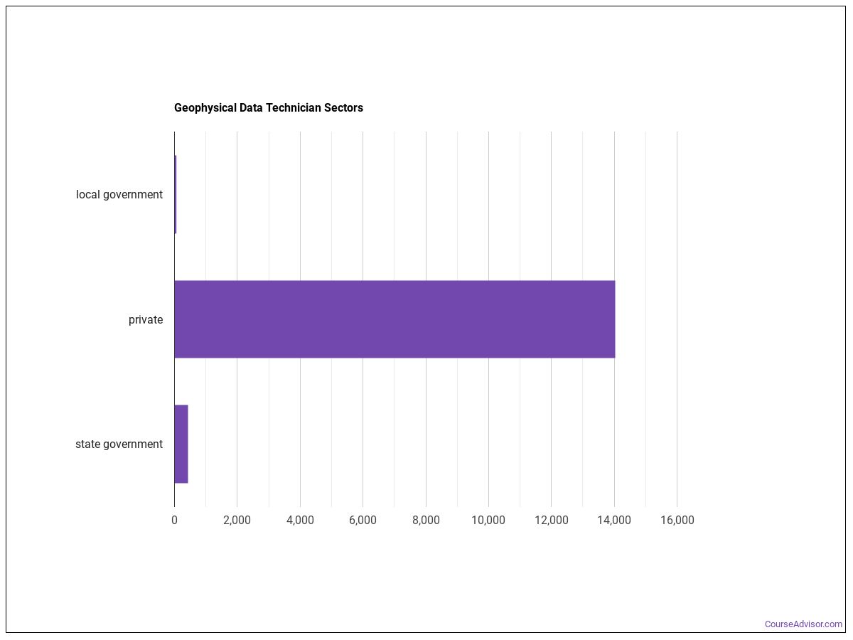
Geophysical Data Technicians work in the following industries:
Other Jobs You May be Interested In
Those thinking about becoming a Geophysical Data Technician might also be interested in the following careers:
Those who work as a Geophysical Data Technician sometimes switch careers to one of these choices:
References:
Image Credit: Jeffrey Beall via Creative Commons Attribution-ShareAlike License
More about our data sources and methodologies.
Featured Schools
 Request Info
|
Southern New Hampshire University You have goals. Southern New Hampshire University can help you get there. Whether you need a bachelor's degree to get into a career or want a master's degree to move up in your current career, SNHU has an online program for you. Find your degree from over 200 online programs. Learn More > |
Course Advisor provides higher-education, college and university, degree, program, career, salary, and other helpful information to students, faculty, institutions, and other internet audiences. Presented information and data are subject to change. Inclusion on this website does not imply or represent a direct relationship with the company, school, or brand. Information, though believed correct at time of publication, may not be correct, and no warranty is provided. Contact the schools to verify any information before relying on it. Financial aid may be available for those who qualify. The displayed options may include sponsored or recommended results, not necessarily based on your preferences.
© Course Advisor – All Rights Reserved.