Remote Sensing Technicians: Career Overview
Apply remote sensing technologies to assist scientists in areas such as natural resources, urban planning, or homeland security. May prepare flight plans or sensor configurations for flight trips.
Featured schools near , edit
What Tasks Do Remote Sensing Technicians Perform?
The core tasks performed by remote sensing technicians include:
- Collect geospatial data, using technologies such as aerial photography, light and radio wave detection systems, digital satellites, or thermal energy systems.
- Verify integrity and accuracy of data contained in remote sensing image analysis systems.
- Integrate remotely sensed data with other geospatial data.
- Consult with remote sensing scientists, surveyors, cartographers, or engineers to determine project needs.
- Adjust remotely sensed images for optimum presentation by using software to select image displays, define image set categories, or choose processing routines.
- Manipulate raw data to enhance interpretation, either on the ground or during remote sensing flights.
- Merge scanned images or build photo mosaics of large areas, using image processing software.
- Participate in the planning or development of mapping projects.
What Remote Sensing Technicians Need to Know
Top remote sensing technicians draw on a mix of skills and domain knowledge.
Key Skills
The abilities that matter most in this role, rated on an importance scale of 0 to 5:
Core Knowledge
Related Job Titles
Common job titles for this role include:
- Commercial Drone Operator
- Commercial Drone Pilot
- Commercial Drone Technician
- Digital Cartographic Technician
- Document Image Technician
- Drone Operator
- Drone Pilot
- Drone Technician
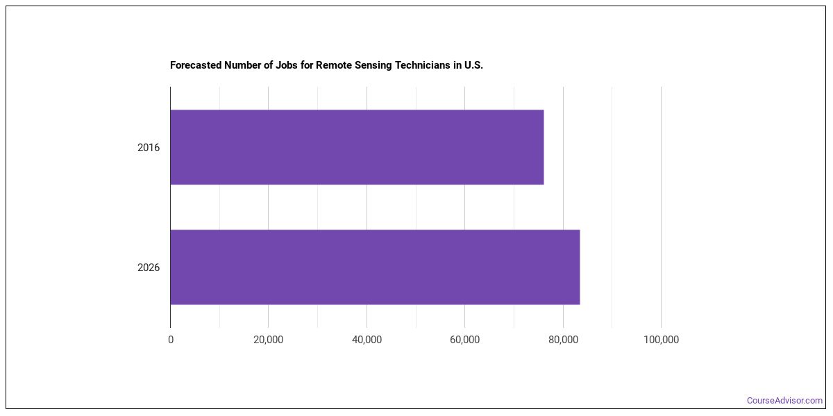
Job Outlook
There are about 31,122 remote sensing technicians working in the United States today. Employment is projected to decline by -2.2% over the projection horizon.
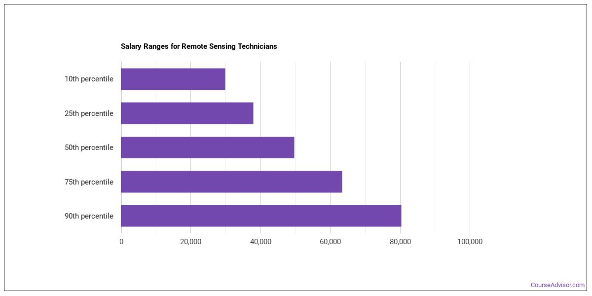
Salary for Remote Sensing Technicians
| Statistic | Value |
|---|---|
| Annual median | $99,834 |
| Hourly median | $48.00 |
| 10th percentile | $70,820 |
| 25th percentile | $85,327 |
| 75th percentile | $114,340 |
| 90th percentile | $128,847 |
Wages vary widely based on experience, location, and industry.
Remote Sensing Technicians Salary by State
| State | Annual median salary |
|---|---|
| California | $75,780 |
| Oklahoma | $73,940 |
| Connecticut | $72,090 |
| District of Columbia | $70,680 |
| Washington | $70,650 |
| Alaska | $68,600 |
| Maryland | $67,040 |
| North Carolina | $66,090 |
| North Dakota | $65,800 |
| Georgia | $65,070 |
| Vermont | $63,960 |
| Massachusetts | $62,610 |
| New York | $62,500 |
| Colorado | $62,180 |
| Wyoming | $61,740 |
| Kansas | $61,740 |
| Indiana | $61,610 |
| Virginia | $61,470 |
| Rhode Island | $61,160 |
| Kentucky | $60,340 |
| West Virginia | $60,250 |
| South Carolina | $59,900 |
| Maine | $59,690 |
| Mississippi | $59,600 |
| Pennsylvania | $58,590 |
| New Hampshire | $57,880 |
| Florida | $57,840 |
| New Mexico | $57,180 |
| New Jersey | $56,950 |
| Oregon | $55,890 |
| Illinois | $54,720 |
| Arkansas | $54,290 |
| Nevada | $53,990 |
| Alabama | $53,910 |
| Utah | $52,400 |
| Missouri | $52,400 |
| Nebraska | $52,000 |
| Michigan | $51,400 |
| Montana | $50,510 |
| Texas | $48,550 |
| Louisiana | $48,240 |
| Idaho | $47,870 |
| Tennessee | $47,520 |
| Arizona | $47,330 |
| Minnesota | $47,130 |
| Ohio | $46,540 |
| Hawaii | $45,710 |
| Wisconsin | $44,120 |
| Iowa | $44,040 |
| South Dakota | $41,250 |
| Puerto Rico | $37,710 |
Pay by U.S. Region
Earnings for remote sensing technicians shift depending on where you work. Top regions by median wage:
| Region | Median annual wage | Share of U.S. jobs | Location quotient |
|---|---|---|---|
| Far Western US | $70,824 | 19.9% | 1.39 |
| New England | $62,638 | 2.0% | 1.00 |
| Middle Atlantic | $61,924 | 21.0% | 1.58 |
| Southeast | $59,820 | 22.6% | 1.17 |
| Rocky Mountains | $56,011 | 5.8% | 1.50 |
| Plains States | $51,642 | 8.4% | 1.29 |
| Great Lakes | $51,001 | 7.1% | 0.52 |
| Southwest | $49,985 | 12.4% | 1.11 |
Where the Jobs Cluster
| Metro area | State | Median annual wage | Employment |
|---|---|---|---|
| Bridgeport-Stamford-Danbury, CT | CT | $112,040 | 50 |
| Oklahoma City, OK | OK | $106,850 | 240 |
| Spartanburg, SC | SC | $105,350 | 260 |
| Augusta-Richmond County, GA-SC | GA | $86,350 | 150 |
| Bakersfield-Delano, CA | CA | $82,290 | 70 |
| Atlanta-Sandy Springs-Roswell, GA | GA | $81,030 | 1,880 |
| San Francisco-Oakland-Fremont, CA | CA | $80,100 | 2,000 |
| Los Angeles-Long Beach-Anaheim, CA | CA | $79,360 |
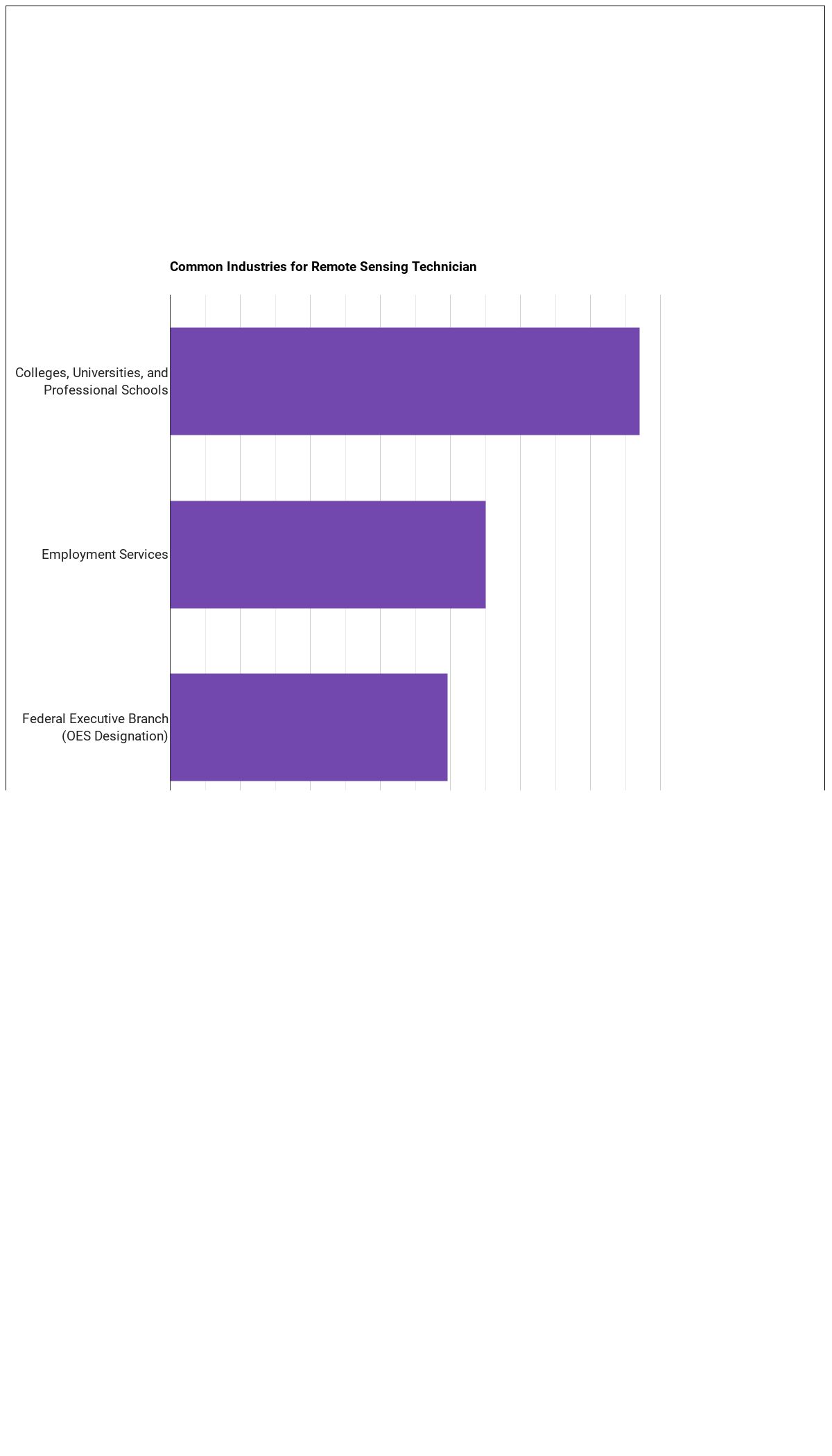
Industry Breakdown
The bulk of remote sensing technicians are concentrated in the following sectors:
| Industry | Employment | Median annual wage |
|---|---|---|
| Educational Services | 21,830 | $60,130 |
| Professional, Scientific, and Technical Services | 16,840 | $62,460 |
| Manufacturing | 8,800 | $62,990 |
| Administrative and Support and Waste Management and Remediation Services | 5,980 | $46,750 |
| Health Care and Social Assistance | 4,050 | $59,370 |
| Wholesale Trade | 1,210 | $60,980 |
| Management of Companies and Enterprises | 730 | $64,720 |
| Finance and Insurance | 670 | $61,600 |
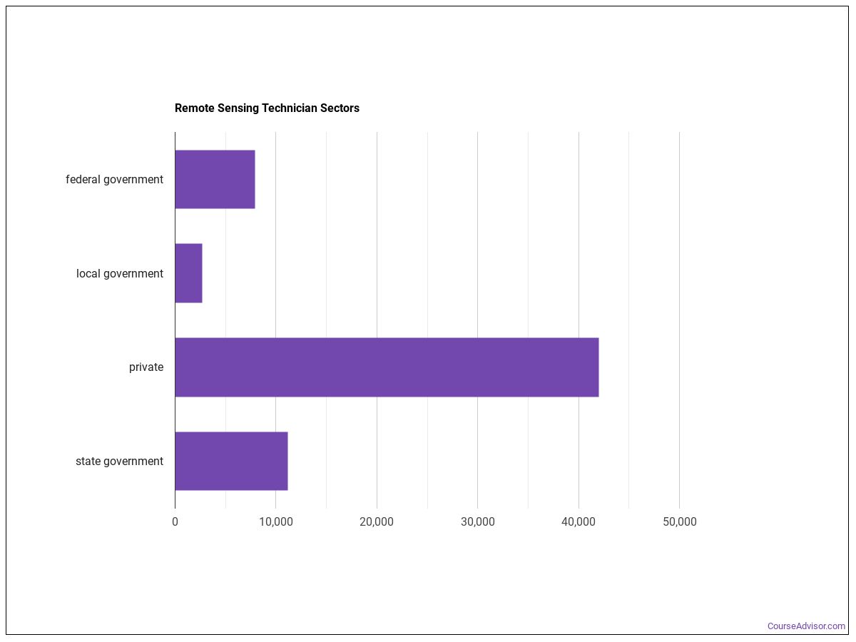
Remote Sensing Technicians work in the following industries:
Tools and Technology
- Graphics or photo imaging software: Adobe Creative Cloud software (hot technology)
- Graphics or photo imaging software: Adobe Photoshop (hot technology)
- Web platform development software: AJAX (hot technology)
- Data base user interface and query software: Amazon Elastic Compute Cloud EC2 (hot technology)
- Data base user interface and query software: Amazon Web Services AWS software (hot technology)
- Expert system software: Ansible software (hot technology)
- Project management software: Atlassian Confluence (hot technology)
- Project management software: Atlassian JIRA (hot technology)
- Computer aided design CAD software: Autodesk AutoCAD (hot technology)
- Computer aided design CAD software: Bentley MicroStation (hot technology)
- Development environment software: C (hot technology)
- Object or component oriented development software: C# (hot technology)
What the Workplace Is Like
Daily working conditions for remote sensing technicians reflects the following characteristics:
- Indoors, Environmentally Controlled
- Importance of Being Exact or Accurate
- Face-to-Face Discussions with Individuals and Within Teams
- Spend Time Sitting
Education and Training
Entry-level remote sensing technicians positions require a bachelor’s degree as the typical entry-level education. This occupation sits in Considerable Preparation Needed (Job Zone 4), reflecting the level of preparation typically expected.
Other Careers to Consider
Similar Occupations
- Software Developers (Supplemental)
- Geographic Information Systems Technologists and Technicians (Primary-Long)
- Cartographers and Photogrammetrists (Primary-Long)
- Surveyors (Supplemental)
- Geodetic Surveyors (Primary-Short)
- Aerospace Engineers (Primary-Long)
- Radio Frequency Identification Device Specialists (Supplemental)
- Robotics Engineers (Supplemental)
Where to Study
Future remote sensing technicians typically earn programs in:
Homeland Security, Law Enforcement, Firefighting and Related Protective Services
4 programs across 2 majors
Science Technologies/Technicians
4 programs across 3 majors
Physical Sciences
3 programs across 2 majors
Social Sciences
1 programs across 1 majors
References
Statistics shown above are sourced from the following authoritative sources:
- U.S. Bureau of Labor Statistics — Occupational Employment and Wage Statistics (OEWS) for employment and wage data by state and industry.
- BLS Employment Projections for total employment and growth forecasts.
- O*NET (Occupational Information Network) for skills, knowledge, tasks, work activities, work context, technology, and education-zone data.
SOC code: 19-4099.03 (Life, Physical, and Social Science Technicians, All Other).
Course Advisor provides higher-education, college and university, degree, program, career, salary, and other helpful information to students, faculty, institutions, and other internet audiences. Presented information and data are subject to change. Inclusion on this website does not imply or represent a direct relationship with the company, school, or brand. Information, though believed correct at time of publication, may not be correct, and no warranty is provided. Contact the schools to verify any information before relying on it. Financial aid may be available for those who qualify. The displayed options may include sponsored or recommended results, not necessarily based on your preferences.
© Course Advisor – All Rights Reserved.