Remote Sensing Scientists and Technologists: Career Profile
Apply remote sensing principles and methods to analyze data and solve problems in areas such as natural resource management, urban planning, or homeland security. May develop new sensor systems, analytical techniques, or new applications for existing systems.
Featured schools near , edit
What Do Remote Sensing Scientists and Technologists Take On?
Typical responsibilities of remote sensing scientists and technologists span:
- Manage or analyze data obtained from remote sensing systems to obtain meaningful results.
- Analyze data acquired from aircraft, satellites, or ground-based platforms, using statistical analysis software, image analysis software, or Geographic Information Systems (GIS).
- Integrate other geospatial data sources into projects.
- Organize and maintain geospatial data and associated documentation.
- Compile and format image data to increase its usefulness.
- Prepare or deliver reports or presentations of geospatial project information.
- Discuss project goals, equipment requirements, or methodologies with colleagues or team members.
- Process aerial or satellite imagery to create products such as land cover maps.
What Remote Sensing Scientists and Technologists Need to Know
Top remote sensing scientists and technologists draw on a mix of skills and domain knowledge.
Most Important Skills
The competencies most important for this role, rated on an importance scale of 0 to 5:
Top Knowledge Areas
Related Job Titles
Common job titles for this role include:
- All Source Intelligence Analyst
- Commercial Drone Operator
- Commercial Drone Pilot
- Drone Operator
- Drone Pilot
- Geospatial Image Analyst
- Geospatial Intelligence Analyst
- Image Scientist
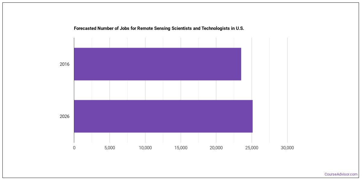
Job Outlook
There are roughly 175,921 remote sensing scientists and technologists working in the United States today. Employment is projected to grow by +7.4% over the projection horizon.
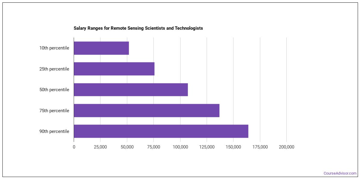
How Much Do Remote Sensing Scientists and Technologists Make?
| Statistic | Value |
|---|---|
| Annual median | $73,261 |
| Hourly median | $35.22 |
| 10th percentile | $50,753 |
| 25th percentile | $62,007 |
| 75th percentile | $84,516 |
| 90th percentile | $95,770 |
Pay can vary substantially based on experience, location, and industry.
Pay by State
| State | Annual median salary |
|---|---|
| Minnesota | $167,110 |
| District of Columbia | $157,980 |
| Massachusetts | $143,640 |
| Maryland | $143,210 |
| North Dakota | $138,430 |
| Washington | $135,080 |
| South Carolina | $134,430 |
| Georgia | $131,770 |
| Alabama | $131,560 |
| Colorado | $130,290 |
| California | $128,250 |
| Virginia | $128,040 |
| New Mexico | $127,090 |
| Florida | $122,600 |
| Arizona | $119,920 |
| Kansas | $114,820 |
| New York | $114,430 |
| Alaska | $114,120 |
| Tennessee | $113,730 |
| North Carolina | $111,490 |
| Hawaii | $111,380 |
| Missouri | $111,170 |
| Oklahoma | $110,300 |
| Oregon | $109,120 |
| Illinois | $108,630 |
| Utah | $106,850 |
| Mississippi | $105,500 |
| Michigan | $105,480 |
| Ohio | $102,750 |
| New Jersey | $102,350 |
| Nebraska | $99,490 |
| Pennsylvania | $98,860 |
| Texas | $98,460 |
| Wisconsin | $93,910 |
| Idaho | $89,860 |
| Montana | $85,160 |
| New Hampshire | $85,030 |
| Kentucky | $80,870 |
| Iowa | $79,790 |
| Louisiana | $74,990 |
| Wyoming | $65,960 |
| Indiana | $64,300 |
| Puerto Rico | $51,530 |
Top-Paying U.S. Regions
Compensation for remote sensing scientists and technologists shift depending on where you work. Top regions by median wage:
| Region | Median annual wage | Share of U.S. jobs | Location quotient |
|---|---|---|---|
| Plains States | $147,425 | 4.1% | 1.07 |
| Middle Atlantic | $126,655 | 26.6% | 3.33 |
| Far Western US | $126,507 | 14.8% | 1.04 |
| Rocky Mountains | $116,450 | 5.7% | 1.68 |
| Southeast | $115,615 | 22.7% | 1.59 |
| New England | $111,882 | 3.9% | 1.40 |
| Southwest | $103,415 | 10.4% | 0.94 |
| Great Lakes | $85,406 | 11.6% | 1.57 |
Highest-Paying Metro Areas for Remote Sensing Scientists and Technologists
| Metro area | State | Median annual wage | Employment |
|---|---|---|---|
| San Jose-Sunnyvale-Santa Clara, CA | CA | $174,810 | 300 |
| Providence-Warwick, RI-MA | RI | $170,960 | 100 |
| Minneapolis-St. Paul-Bloomington, MN-WI | MN | $168,870 | 540 |
| Washington-Arlington-Alexandria, DC-VA-MD-WV | DC | $162,610 | 2,720 |
| Palm Bay-Melbourne-Titusville, FL | FL | $155,080 | 80 |
| Santa Maria-Santa Barbara, CA | CA | $147,320 | 30 |
| Bremerton-Silverdale-Port Orchard, WA | WA | $142,810 | 30 |
| Boston-Cambridge-Newton, MA-NH | MA | $141,980 | 520 |
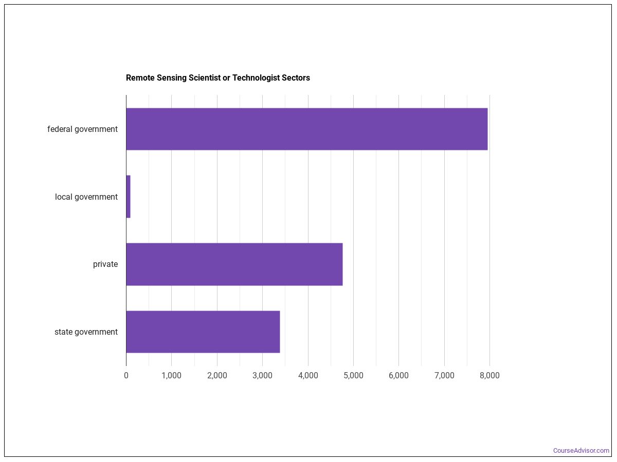
Industry Breakdown
The bulk of remote sensing scientists and technologists are concentrated in the following sectors:
| Industry | Employment | Median annual wage |
|---|---|---|
| Professional, Scientific, and Technical Services | 4,280 | $121,490 |
| Educational Services | 3,700 | $80,130 |
| Manufacturing | 1,300 | $145,640 |
| Management of Companies and Enterprises | 490 | $168,290 |
| Administrative and Support and Waste Management and Remediation Services | 220 | $122,660 |
| Utilities | 120 | $101,560 |
| Health Care and Social Assistance | 40 | $90,920 |
| Other Services (except Public Administration) | 40 | $114,790 |
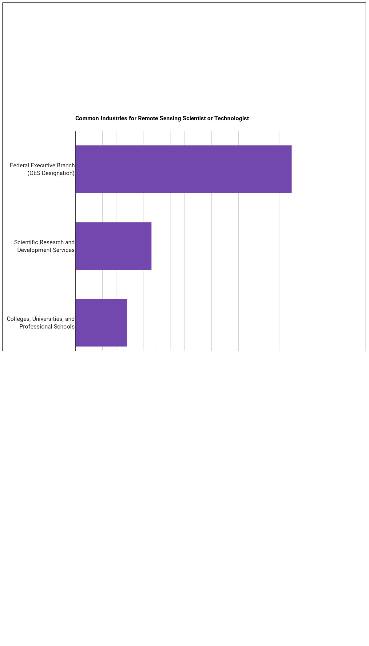
Below are examples of industries where remote sensing scientists and technologists work:
Software Remote Sensing Scientists and Technologists Use
- Graphics or photo imaging software: Adobe Creative Cloud software (hot technology)
- Data base management system software: Amazon DynamoDB (hot technology)
- Data base user interface and query software: Amazon Elastic Compute Cloud EC2 (hot technology)
- Data base user interface and query software: Amazon Redshift (hot technology)
- Cloud-based management software: Amazon Web Services AWS CloudFormation (hot technology)
- Data base user interface and query software: Amazon Web Services AWS software (hot technology)
- Expert system software: Ansible software (hot technology)
- Data base management system software: Apache Hadoop (hot technology)
- Data base management system software: Apache Hive (hot technology)
- Development environment software: Apache Kafka (hot technology)
- Project management software: Atlassian JIRA (hot technology)
- Operating system software: Bash (hot technology)
The Day-to-Day Environment
Daily working conditions for remote sensing scientists and technologists is shaped by the following characteristics:
- Importance of Being Exact or Accurate
- Indoors, Environmentally Controlled
- Spend Time Sitting
- Telephone Conversations
How to Become Remote Sensing Scientists and Technologists
Most remote sensing scientists and technologists positions require a bachelor’s degree as the typical entry-level education. The role falls in Considerable Preparation Needed (Job Zone 4), signaling the level of preparation typically expected.
Other Careers to Consider
Similar Occupations
- Geographic Information Systems Technologists and Technicians (Primary-Short)
- Cartographers and Photogrammetrists (Primary-Long)
- Geodetic Surveyors (Primary-Short)
- Aerospace Engineers (Primary-Long)
- Electronics Engineers, Except Computer (Supplemental)
- Radio Frequency Identification Device Specialists (Supplemental)
- Robotics Engineers (Supplemental)
- Aerospace Engineering and Operations Technologists and Technicians (Supplemental)
Where to Study
Future remote sensing scientists and technologists commonly pursue programs in:
Multi/Interdisciplinary Studies
2 programs across 2 majors
Physical Sciences
1 programs across 1 majors
About the Data
This profile draws on the following authoritative sources:
- U.S. Bureau of Labor Statistics — Occupational Employment and Wage Statistics (OEWS) for employment and wage data by state and industry.
- BLS Employment Projections for total employment and growth forecasts.
- O*NET (Occupational Information Network) for skills, knowledge, tasks, work activities, work context, technology, and education-zone data.
SOC code: 19-2099.01 (Physical Scientists, All Other).
Course Advisor provides higher-education, college and university, degree, program, career, salary, and other helpful information to students, faculty, institutions, and other internet audiences. Presented information and data are subject to change. Inclusion on this website does not imply or represent a direct relationship with the company, school, or brand. Information, though believed correct at time of publication, may not be correct, and no warranty is provided. Contact the schools to verify any information before relying on it. Financial aid may be available for those who qualify. The displayed options may include sponsored or recommended results, not necessarily based on your preferences.
© Course Advisor – All Rights Reserved.